**As always, supporting photos are here.
We arrived in Casablanca from Istanbul a little after 3:30am so I curled up on the tile for the world’s least comfortable nap while Rich paced the airport. A few hours later, car rental office opened, we collected our car and hit the road northwards. We had a six-hour drive to reach Chefchaouen – and by “we” I mean “Rich.”
Our first visit to Morocco was 10 years ago, when we spent a long weekend in Marrakesh. That visit was enough to show me how little I knew about this North African country and it piqued my interest in what lay beyond the boundaries of the city and the Atlas mountains – I swore to come back one day. As we headed north from Casablanca, we marvelled at the undulating Hills filled with olive groves, sheep, and often crumbling ochre adobe buildings. Had I been blindfolded and teleported to any given spot on that northern highway, I likely would’ve sworn that I was in Italy.
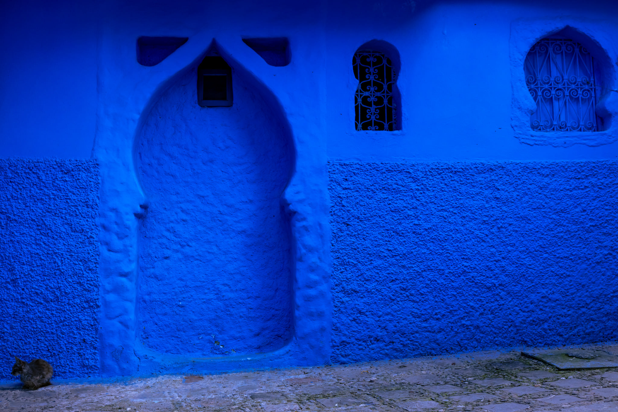
Alongside Jodhpur, Chefchaouen was the city I was most looking forward to photographing on this trip because of its reputation for holding countless shades of blue. After visiting Jodhpur, I learned to temper my expectations because, while the photos might show a city glowing blue, the reality is that the upkeep is much harder to maintain and the results might be good but not outstanding.
As we approached the city, I could see countless blue buildings interspersed between white and tan and ochre and wondered if maybe we were going to be in the same situation once again: a great reputation with mediocre execution. However, I would quickly learn that this was not the case.
On our first evening, we made a “quick” pitstop to collect some basic groceries and were reminded that Morocco isn’t a “one stop shop” culture. Four stores later, we unloaded our bags into our apartment and took a short walk down the street to enjoy the sunset view of the hills from our neighbourhood 2 km outside of the medina before I excitedly dug into the kitchen and whipped up a meal for the first time in three months.
The following morning, we walked into the medina via the fish market and the main plaza, taking in the palm trees and the bougainvillea and the colour-coordinated detailing on the tiles of the community fountains. I spotted a bronze frog on the central fountain – a little reminder of my grandfather, who collected frogs – and smiled to think how happy my Papa would be to hear about our adventures this year.
Within two minutes of arriving in the medina, it was very clear that maintaining the paintwork is of top priority in Chefchaouen. Every wall was blue. Not just one shade of blue, but as many shades of azure and cerulean as you can possibly come up with, and then about five more. It was like walking through a Dulux paint swatch.
I photographed it all with glee in my heart.
We quickly realized that the primary market for Chefchaouen is Spanish tourists – so much so that restaurant servers and shopkeepers default to speaking to you in Spanish before trying any other language. And when you look at a map, it’s easy to see why: a one-hour ferry from Tangier lands you in Spain, and a two hour drive from Tangier puts you in Chefchaouen.
We explored dead ends and sharp bends, alleyways and shopfronts, then made our way up through the hills to the edge of the medina, where the city walls still stand. From that elevated viewpoint, you can see down into town as well as out across the hills to the peaks and valleys in the distance.
On our second day, we got an early start and headed out into the mist along a rural route to the Rif Mountains, where we planned to hike to Akchour Falls and God’s Bridge, a natural limestone arch in a canyon.
This would be a good time to note that we had read this hike was highly recommended and sounded great, but did very little research as to the details except for downloading the route on AllTrails. Historically, I have learned that AllTrails loves nothing more than doing you dirty – and yet I seem to keep trusting it.
The hike to the falls once again revealed my ignorance about the gorgeous variety of landscapes that Morocco has to offer. Our route took us 6kms into the mountains along a lushly forested rocky ravine under the shade of massive trees as the perfectly clear water moved through in small cascades, forming small sandy pools that begged to be swum in along the way. We crisscrossed a small river more times than I can count on “bridges” that ranged from concrete blocks to a few sticks and from rocks to haphazard wooden ladders. Despite a few tricky moments, I’m pleased to report that no accidental swims were had.
Along the shallow sections of the river, small tea shops were being set up for the day, with shop owners bringing out plastic chairs and tables to put along the waterfront while their fires burned down to the more functional coals needed for their teapots and tagines. It was clear that we were on quite a popular route and that it would likely get busier as the morning wore on. We’d made the right choice by getting an early start.
The further we got from the parking area, the quieter the route got, and soon enough we had only our thoughts and one another for company. We chattered our way along the moderately challenging route until, soon enough, we could hear the kind of rushing water that only comes from waterfalls – and pretty good-sized ones.
As we rounded a bend, the top of the waterfall came into view. We scrambled over some rocks to take in its full height and laughed when we realised that one enterprising tea shop owner had even set up a table on a crossing so that the river flowed beneath you as you looked at the falls. Mint tea with a view sounded perfect right about then, so we placed our order, grabbed a seat, and marvelled as the tea shop owner nimbly hopped along the rocks with his tea caddy, ready with our glasses.
After plenty of photos and a little hit of caffeine, we retraced our steps back towards the parking lot, noticing a huge increase in traffic and a steep decline in the use of trail etiquette. So, once we reached a section where the footing was less likely to kill me, we ran – because just about anyone will move out of the way when people are running at them.
After 12kms of hiking, we veered left to take the trail to God’s Bridge, passing countless tables and chairs and surprisingly raucous visitors along the riverbank, then veered right onto a trail that would skirt around them so that we could avoid all of the commotion. Critical second error (the first being not reading about this trail).
The trail descended into chaos faster than a preschooler’s birthday party after ice cream. The gradient was steeper than many shoes could tolerate (hmm… maybe this should’ve been a warning?) and the dry terrain meant we did some slipping on loose dirt and gravel. I commented that the route down was going to be exciting.
*cue ominous foreshadowing music*
The hill was so steep that my trail running instincts kicked in – and probably not in a good way – so my head went down and I breathed through it without thinking about what was to come. Some critical thinking probably would’ve been helpful at that point, but when your brain is oxygen-starved from near-hyperventilation, who wants to spare energy for thinking?! Clearly not me. As the trail narrowed to not much more than a goat track, we kept climbing. And climbing. And we began to wonder if this thing would ever end. If you’ve been following this blog, you might recall from the Himalayan portion (hell, even the Pekoe Trail section from way back in Sri Lanka – will we ever learn?!) that we’re great at hiking, but not so great at rest stops when that’s what might really be in our best interest.
So we carried onwards.
When we finally caught sight of the arch across the canyon, we were each breathless, sweating like a parent being asked about the existence of the Tooth Fairy, Santa AND the Easter Bunny all at the same time, and completely over this hike. We could see that the route kept going along a narrow ridge and then climbed again before crossing onto the arch (where there was, you guessed it: a tea shop). We didn’t even want to go on the arch! We’d hoped to get a clear view through it, but the path wasn’t going to give us that. We admitted defeat and turned back on ourselves.
On the way back down, I discovered that my prediction about treacherous footing was more true than I’d even realised. After a few mildly terrifying slides on especially steep sections, I slowed my pace right down until it felt like I was tiptoeing down the canyon. Rich and I had spaced ourselves out so that if one of us slid, we wouldn’t take the other out, since the drop over the edge varied from uncomfortable to precipitous.
About midway down the trail, Rich took one step that led to his feet going out from underneath him. In his attempt to right himself he lost his balance, which sent him head first and backwards over the edge of the trail behind me. In the resulting commotion, I saw his torso disappear into a bush and, fearing I’d just watched him literally dive off a cliff, raced to grab his ankles before he slid any further. When it became clear that his slide had abruptly halted, we each took a deep, shaky breath and then took stock of the situation while the sound of my heartbeat drumming of my ears gradually subsided.
Rich was suspended on the downhill in a hawthorn bush, with the trunk of the bush as a handhold, his legs trapped from calf to ankle by my hands and body weight. Two Moroccan girls who had just passed us on the trail each stood frozen in shock, apparently unable to come help, but also unable to carry on. We assured them that we were okay and proceeded to slowly right ourselves.
How Rich managed to walk away from that situation with only a few minor grazes is nothing short of a miracle. However, when he asked why I hadn’t taken a photo, I began thinking of myriad ways in which he might not walk away from the situation at all. On the other hand, I had managed to drag my kneecap across the trail while diving to pin his legs to the ground, so had some nasty trail rash that was already leaking down my leg and causing quite the sting.
What followed was a very quiet 2.5-km walk back to the car, where I briefly lost my composure. It turns out that thinking you’ve just watched your husband die takes quite a toll on you… We silently set off for home – and the first aid kit. I bandaged myself up and we had a quiet night with delicious clam pasta.
The next morning, I discovered that my bandage job had presumed that my wound was far less significant than it actually was. It turns out I’d lost about a third of the entire surface area of my knee; however, I’d put tape over some of that. The stream of words that flowed through my brain as I removed that tape off my fresh wound was as blue as the city of Chefchaouen itself.
I paid a little more attention to the edges when I rebandaged, then we went into town for one more (slow) exploration of the alleys of Chefchaouen before heading for Morocco’s first city: Fès.
Oh, and the kicker? There’s a ground-level trail that gives a beautiful view through the arch and into the canyon. Damn you, AllTrails.
Grateful for: blue paint, hawthorn and gauze